Standardizing Spatial Intelligence with the Model Context Protocol
Modern applications increasingly rely on location-based data for critical operations, from optimizing delivery routes to managing city-scale infrastructure projects. The emerging challenge is enabling AI agents to process and act on spatial information rather than simply rendering it on maps. Traditional approaches to connecting AI systems with geographic tools create fragile, inconsistent integrations that lack standardization and fail as complexity grows. The Model Context Protocol (MCP), now an open standard under the Linux Foundation's Agentic AI Foundation, provides a structured framework for AI agents to interact with external tools reliably. Applied to geographic systems, geospatial MCP servers create a robust execution layer that enables AI agents to perform spatial operations with consistency and oversight. This guide examines the architecture and implementation considerations for building production-ready geospatial MCP servers that power location-intelligent AI applications.
The Fragmentation Problem in Spatial AI Systems
When AI agents perform location-based tasks, they typically interact with multiple geographic services in sequence. A common workflow might involve converting an address to coordinates, computing a travel path, and verifying whether that path intersects restricted areas. Without standardized interfaces, each operation requires a separate API call, and each service returns data formatted differently. Development teams working on similar features rebuild identical functionality using incompatible approaches. The absence of a unified contract means no shared interface exists across the system.
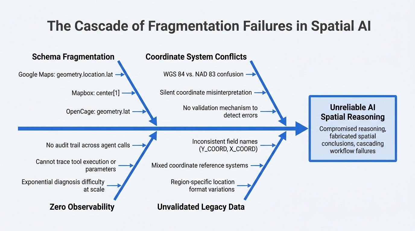
The schema variation across geocoding providers demonstrates this fragmentation clearly. Google Maps returns latitude as geometry.location.lat, while Mapbox uses center[1] and OpenCage employs geometry.lat. Each service structures the same fundamental data point differently. The problem intensifies when legacy municipal databases enter the equation, often using field names like Y_COORD and X_COORD while operating in entirely different coordinate reference systems such as NAD 83 instead of the standard WGS 84. AI agents have no reliable method to interpret these results without custom parsing logic written specifically for each data source.
Observability becomes nearly impossible in these fragmented architectures. Platform teams cannot trace which spatial tool executed, what parameters it received, or why it produced unexpected results. When a routing calculation returns incorrect output, no audit trail connects the initial geocoded input to the final result. Diagnosing failures grows exponentially harder when multiple agents simultaneously access the same spatial services with different assumptions and expectations.
Enterprise spatial data compounds these challenges significantly. Municipal systems and legacy databases produce inconsistent field naming conventions, mixed coordinate reference systems, and region-specific location formats that vary by geography. When this unvalidated data flows directly to language models, the result is compromised reasoning and fabricated spatial conclusions. An agent tasked with identifying the nearest warehouse might incorrectly select a facility located 100 miles away because it silently confused coordinate systems, with no validation mechanism in place to detect the error. These failures cascade through workflows, producing unreliable results that undermine trust in AI-driven spatial systems. The lack of standardization, governance, and observability makes direct API integration patterns unsuitable for production spatial AI applications at scale.
How the Model Context Protocol Standardizes Tool Access
The Model Context Protocol establishes a standardized method for AI agents to interact with external tools through a well-defined interface. Originally launched by Anthropic in November 2024, the protocol transitioned to the Agentic AI Foundation under the Linux Foundation in December 2025, with backing from major technology companies including Anthropic, Block, OpenAI, Google, Microsoft, and AWS. MCP operates as a JSON-RPC 2.0 interface that creates clear separation between AI decision-making and tool execution. The agent determines which actions to take, while the MCP server manages the technical implementation of those actions.
The protocol operates through a structured three-phase connection lifecycle. During initialization, the server broadcasts its available tools, allowing the agent or any MCP client to dynamically discover callable capabilities. The operation phase involves the agent transmitting JSON-RPC requests to execute those tools. Finally, the shutdown phase ensures the connection terminates cleanly. This lifecycle design means agents never require hardcoded knowledge of available tools, instead discovering capabilities dynamically at runtime.
Tool discovery happens through a practical mechanism during the initialization step. When the server receives a tools/list request, it responds with a manifest of available capabilities. For example, a reverse geocoding tool declaration includes its name, a description explaining it converts coordinates to structured addresses, and an input schema defining required parameters. The schema specifies that latitude must be a number between -90 and 90, while longitude must fall between -180 and 180, with both parameters marked as required. This JSON schema validation occurs before execution, ensuring data integrity.
The protocol supports two primary transport mechanisms for different deployment scenarios. Stdio transport serves local or desktop client implementations where the server operates as a subprocess. Streamable HTTP represents the appropriate choice for networked production environments where multiple agents or services require network access to the server. Engineers should note that the earlier Server-Sent Events standalone transport is deprecated in the current specification and should not form the foundation of new implementations. While Streamable HTTP may utilize SSE internally as its streaming mechanism, the deprecation applies specifically to SSE as a standalone transport option rather than as an underlying protocol component. This transport flexibility allows MCP to adapt to different architectural requirements while maintaining consistent tool invocation semantics.
Core Components of a Geospatial MCP Server
A geospatial MCP server exposes spatial capabilities as discrete, validated tools that AI agents can invoke safely. Unlike direct API integrations, these tools provide structured interfaces for common geographic operations including spatial data retrieval, computational geometry, workflow orchestration, address resolution, route calculation, and polygon analysis. Each tool declaration includes schema validation that enforces constraints before execution, preventing malformed requests from reaching underlying spatial engines.
Spatial data tools provide access to geographic datasets through normalized interfaces. Rather than exposing raw database schemas or vendor-specific formats, these tools return data in consistent structures regardless of the underlying source. A tool retrieving property boundaries might pull from a PostGIS database, a municipal GIS system, or a commercial data provider, but always returns geometry in a standardized format with predictable field names. This normalization layer shields agents from the complexity of heterogeneous spatial data sources.
Spatial operation tools encapsulate computational geometry functions that agents need for analysis. These include buffer generation around points or lines, intersection detection between geometries, distance calculations, and containment checks. Each operation accepts validated inputs and returns results in consistent units and coordinate systems. A buffer tool might accept a point geometry and radius in meters, automatically handling coordinate system transformations and returning a polygon geometry representing the buffered area. This abstraction prevents agents from directly managing projection mathematics or unit conversions.
Workflow tools chain multiple spatial operations into governed sequences. A site suitability tool might internally geocode an address, buffer the resulting point, query parcel data within that buffer, and filter results based on zoning criteria. From the agent's perspective, this appears as a single tool call with high-level parameters. The server manages the execution sequence, intermediate data transformations, and error handling. This pattern prevents agents from needing to understand complex spatial workflows while ensuring operations execute in the correct order.
Geocoding and routing tools represent essential capabilities for location-aware applications. Geocoding tools convert addresses to coordinates and reverse geocode coordinates to addresses, handling address normalization and ambiguity resolution. Routing tools calculate paths between locations, supporting different transportation modes and constraint parameters like avoiding toll roads or optimizing for time versus distance. Polygon analysis tools enable zone verification, checking whether points or routes intersect with defined geographic boundaries such as delivery zones, restricted areas, or service regions. Each tool category exposes spatial domain expertise through simple, validated interfaces that agents can reliably invoke.
Conclusion
Building reliable location-aware AI systems requires more than connecting agents to mapping APIs. The fragmentation inherent in direct spatial service integrations creates maintenance burdens, observability gaps, and reliability issues that worsen as systems scale. An mcp server geospatial architecture addresses these challenges by establishing a standardized execution layer between AI reasoning and geographic operations. This separation enables consistent tool interfaces, governed workflows, and comprehensive observability across spatial interactions.
The practical benefits emerge immediately in production environments. Schema normalization eliminates the parsing complexity that comes from integrating multiple geocoding providers or legacy municipal databases. Validated tool schemas prevent malformed requests from reaching spatial engines, catching errors before execution rather than during runtime. Workflow tools encapsulate complex spatial operation sequences, allowing agents to accomplish sophisticated geographic tasks through simple, high-level calls. OpenTelemetry instrumentation provides the traceability needed to diagnose failures and optimize performance across distributed spatial workflows.
Implementation requires deliberate architectural decisions around schema design, execution ordering, and observability instrumentation. Teams must normalize spatial data structures, validate inputs rigorously, and instrument tool calls comprehensively. The investment pays dividends as agent capabilities expand and spatial workflows grow more complex. Organizations building logistics platforms, urban planning tools, or delivery optimization systems gain a foundation that scales reliably while maintaining governance and auditability. The Model Context Protocol provides the standardization framework; applying it thoughtfully to geospatial operations creates AI systems that reason over location data accurately and reliably in production.